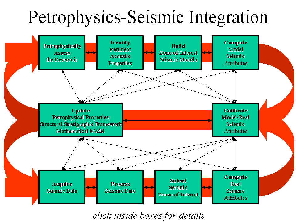
Integration of seismic and petrophysical information (I.e. describing the reservoir) can be approached in many ways; a plan-of-attack should therefore be designed for the specific reservoir problem to be addressed. Seismic-Petrophysics relationships derived for one reservoir usually do not carry-over to another reservoir, particularily if the two reservoirs exist in differing structural/stratigraphic frameworks. There are however, several key steps that form all Seismic-Petrophysics projects. These are outlined in the workflow illustration below. This workflow is never linear (I.e. cookbook-style) and always involves some degree of re-working caused by something being learned in one part of the workflow that impacts other parts of the workflow.
The USP toolkit excels in allowing such integration. It is to seismic signal analysis and processing, what spreadsheet functionality is to basic data analysis. Other seismic processing packages are relatively rigid in their approach to signal analysis and processing. They force users to follow a subjective and predetermined processing path. In USP, the user has the freedom to apply any of the over 400 modules to analyze, process, or quality control data at any stage of processing, interpretation or integration. USP lets you think, analyze, and be creative; really get to know the data, determine what needs to be done, then do it.
The ideal time to integrate seismic and petrophysical data is during the interpretive processing stage (I.e., interpretive processing of both petrophysical and seismic data). The earlier in the processing stream these two data types are compared and calibrated, the more likely a reasonable reservoir flow-unit characterization will evolve. If integration is pushed down, after completing the petrophysical characterization, and after seismic data is processed and handed off to the interpreter, the integration will become rigid; dependent on the assumptions built into both the petrophysics and seismic sides of the workflow.
Problems with seismic data processing and petrophysical data processing become most obvious during the integration stage, when mismatches between petrophysical information and geophysical information become evident. If such integration (and problem detection) is done at a late project stage, the interpreter can either force the data together or backup and reprocess the data. In either case, time and quality problem solving is lost.
The petrophysics side of the workflow includes:
Petrophysical Assessment of the Reservoir: Using information obtained from boreholes determine the physical and chemical properties of rocks and their fluid content; determining reservoir characteristics such as reservoir thickness, porosity, permeabilty, hydrocarbon saturation, hydrocarbon mobility. Categorize flow-units.
Identification of Pertinent Acoustic Properties: Understanding the acoustic manifestation of rock and fluid types via methods such as seismic model, petrophysical-acoustic crossplots, and integration of capillary pressure and acoustic data. Can seismic resolve, or at least detect individual flow units or groups of flow-units? If yes, then 3D seismic should be used to map the spatial and vertical flow-unit boudaries and baffles.
Seismic Modeling: Forging an understanding of the acoustic response of the reservoir. This involves building end-member reservoir models from petrophysical rock and fluid types, computing seismic responses for each model, and varying the reservoir thickness/net-to-gross within each model to understand tuning effects. Flow-unit seismic expressions are modeled and understood at this stage.
Attribute Extraction from Seismic Reservoir Models: Characterizing reservoir flow-units via attribute components that comprise the seismic waveform; measuring waveform characteristics for each model and identifying discriminating waveform characteristics.
The seismic side of the workflow includes:
Seismic Data Acquisition: Optimizing parameters for target depth, target geometry, and surface conditions.
Seismic Data Processing: Quality controlling at each step to ensure optimum imaging, Relative amplitude preservation and steep dip preservation. Examine and assess the seismic reservoir map after each processing step to maximize flow-unit imaging.
The common ground between the two sides of the work-flow include:
Calibration of Real Seismic Attributes and Modeled Seismic Attributes: Comparing waveform characteristics derived from real seismic data to waveform characteristics derived from modeled seismic data. Similarities strengthen flow-unit calibration; dissimilarities indicate inadequacies in the data, conceptual framework, and/or the mathematical model. Use the insight and knowledge gained in this step along with 3D seismic to map the three-dimensional flow-unit geometries.
Re-evaluation of Data, Concepts and Methods: Modeled seismic properties rarely match all aspects of real seismic data. Such discrepancies can be caused by incomplete or inadequate flow-unit characterization, inappropriate structural/stratigraphic framework, or deficient mathematical models.
It is impossible to follow each side of the workflow linearly and independently. Learnings from any of the above steps may impact any or all other step(s).